
The Southeastern Anatolia Region extending over wide plains in the Euphrates-Tigris Basin encompass the administrative provinces of Adıyaman, Batman, Diyarbakır, Gaziantep, Kilis, Mardin, Siirt, Şanlıurfa and Şırnak. The surface area of the region bordering with Syria to the south and with Iraq to the southeast is 75,193 square kilometres which corresponds to 9.7% of Turkey’s total surface area. Turkey has in total 8.5 million hectares of irrigable land and GAP’s share in this total is 20 per cent.
The GAP region has total population of 8.5 million, making up 10.7% of Turkey’s total population.
The region also known as “Fertile Crescent” or “Upper Mesopotamia” is admitted as cradle of civilizations in human history. Throughout history, the GAP region served as a bridge between Anatolia and Mesopotamia.
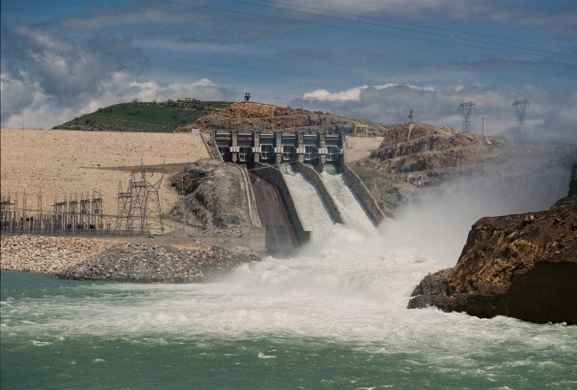
The Euphrates and Tigris, two major streams of Turkey originate from Eastern Anatolia and flow to the Persian Gulf. Precipitation is low in South-eastern Anatolia relative to the other regions of Turkey. It was considered, therefore, to utilize the rich water resources of the region for energy production and irrigation and also to regulate the flow of these two rivers which are otherwise quite irregular.
The decision to utilize water resources rationally goes back to Atatürk, the funding father of Turkish Republic. During those years when the country was making efforts for change and improvement in all spheres the need for electricity came to the fore as the most critical and urgent one. Then, upon the order of Atatürk the Administration for Electricity was established in 1936 as a step to use streams in the country for producing electricity. The Administration started intensive studies with the “Keban Project” including the establishment of observation posts along the Euphrates to examine the flow of the river and draw necessary conclusions.
 Geological and topographical studies on the Keban gorge started in 1938. The Administration gave weight to drillings along both the Euphrates and Tigris in the period 1950-1960. Upon the emergence of new needs the General Directorate of State Hydraulic Works (DSİ) was established in 1954. This led to the emergence of the idea of basin surveys in Turkey and consequently Turkey was divided into 26 water basins in which the DSİ launched its surveys and planning work. As a result of work conducted by the Euphrates Planning Authority established in Diyarbakır in 1961, the “Euphrates Basin Development Report” assessing the irrigation and energy potential of the Euphrates Basin was prepared in 1964. In addition to this report the “Lower Euphrates Development Report” was ready in 1966. Parallel studies relating to the Tigris Basin was conducted by the Diyarbakır Directorate of DSİ.
These works made clear how to go on developing the Lower Euphrates and Tigris Basins and in 1977 it was decided to coin these two basin projects together as the “South-eastern Anatolia Project”. The task of addressing the region of South-eastern Anatolia in the context of integrated regional planning and ensuring the coordination of relevant activities was assigned to the State Planning Organization (DPT).
In 1988, the State Planning Organization (DPT) launched the GAP Master Plan work to address the GAP as an integrated and multi-sector socioeconomic development project. Completed in 1989, this work also included possible management systems and their alternatives for the project.
The GAP Regional Development Administration was established in 1989 to have the Southeastern Anatolia Project carried out by a distinct unit. The unit was tasked to plan for regional development and to steer, monitor and coordinate GAP investments which were undertaken and given effect by different organizations in various sectors.
Contact
: +90 (414) 317 2000: +90 (414) 317 2070
: gap[@]gap.gov.tr
: Doğukent Mah. 104.Cad. No: 1155/2 Karaköprü / ŞANLIURFA
links


GAP Regional Development Administration © 2015